
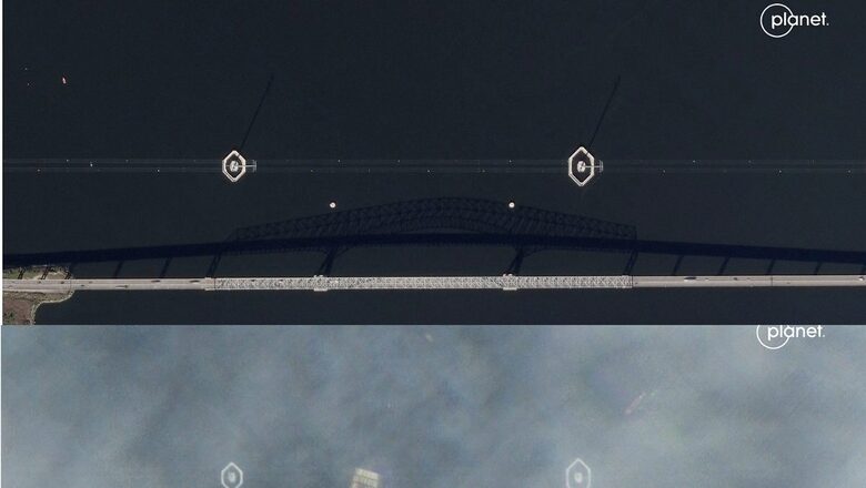
The broken Francis Scott Key Bridge in US’ Baltimore and the wreckage below it in the waters of the Patapsco River were clearly visible in the satellite imagery taken after a cargo ship crashed into the bridge.
A cargo ship departing the Port of Baltimore struck the Francis Scott Key Bridge early Tuesday morning. SkySat images from November 3, 2023 and March 26, 2024 show the bridge before and after its collapse. pic.twitter.com/TemL19XINZ— Planet (@planet) March 26, 2024
Photos obtained by Planet Labs showed the before and after images of the bridge named after the writer of the US national anthem. The new photos show the Dali container ship underneath a section of the bridge in the river. The ship collided with the bridge after it lost power.
The 948-foot vessel collided with the four-lane bridge along Interstate 695 in the wee hours of Tuesday morning. The crew, composed of Indians, called for help before colliding with the major Baltimore bridge.
The satellite images by Planet Labs show what the 2.57 kilometre bridge looked like before the devastating crash.
Photos taken by Planet Labs on March 26 showed the Dali container ship and a collapsed Francis Scott Key Bridge and the search efforts underway around the crash site.
Authorities said they will resume the search on Wednesday morning for six people missing and presumed dead in the wake of the collapse of the Francis Scott Key Bridge. The bridge collapsed after a support column was hit by the Singapore-flagged container ship “Dali”, sending people and vehicles into the Patapsco River.
Two people were rescued on Tuesday.
The eight people were part of a construction crew that was filling potholes on the bridge at the time, according to Rear Admiral Shannon Gilreath of the US Coast Guard.
Gilreath said that there are less chances that those who fell into the river would be found alive due to cold temperatures. “Based on the length of time that we’ve gone in this search, the extensive search efforts that we’ve put into it, the water temperature — that at this point we do not believe that we’re going to find any of these individuals still alive,” Gilreath was quoted as saying by CBS.
About 1.01 km of the bridge fell into the river when the collision occurred. Huge chunks of the bridge can be seen under the water in the satellite photos.


Comments
0 comment