
The study, by 53 scientists from 14 countries including India, was conducted to investigate the cause, scope and impacts of the disaster. New Delhi: The Chamoli disaster in February was triggered by a mix of rock and ice falling from a height of 3,700 meter above the sea level, a new study has revealed.
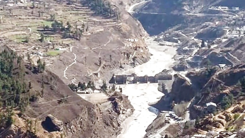
On February 7, a catastrophic mass flow descended the Ronti Gad, Rishiganga, and Dhauliganga valleys in Uttarakhand’s Chamoli, and caused widespread devastation and severely damaged two hydropower projects.
The ‘worst-case rock:ice ratio’ (80:20) resulted in almost complete melting of the glacier ice, the study says. This heightened the mobility of the debris flow and the intensity of the disaster.
The flash flood in Rishiganga washed away a functional Rishiganga small hydro project of 13.2 MW. It also affected the under construction 520 MW NTPC Hydro Power Project downstream at Tapovan on the river Dhauli Ganga. More than 50 people were killed and over 150 went missing on the fateful morning.
While the initial hypotheses suggested a glacial lake outburst flood as the cause of the event, researchers found that there are no glacial lakes large enough to produce a flood anywhere near the site.
The study, by 53 scientists from 14 countries including India, was conducted to investigate the cause, scope and impacts of the disaster.
The team determined that the flood was caused by falling rock and glacier ice that melted on its descent — not by a lake or diverted river — which will help researchers and policymakers better identify emerging hazards in the region.
The study used satellite imagery, seismic records and eyewitness videos to produce computer models of the flow. It was published last week in the Science.
The researcher identified three primary drivers for the severity of the Chamoli disaster: the extraordinary fall height, providing ample gravitational potential energy; the worst-case rock:ice ratio, which resulted in almost complete melting of the glacier ice, enhancing the mobility of the debris flow; and the unfortunate location of multiple hydropower plants in the direct path of the flow.
They found that the giant mass of rock on the Ronti peak had already been moving since 2016, with the largest displacement in the summer months of 2017 and 2018. This movement opened a fracture up to 80m wide in the glacier and into the underlying bedrock.
The study says the nearly 3,700 m vertical drop to the Tapovan HPP was surpassed by only two known events in the historic record — the 1962 and 1970 Huascaran avalanches.
The researchers compared the images and topographic maps from before and after the event to document all of the changes and reconstruct the sequence of events.
As per the study, at least 35 million cubic yards of rock and glacier ice were missing from the site — enough material to cover Washington, D.C., with a half-foot-deep layer. “This was the source of a giant landslide that triggered the cascade of events, and caused immense death and destruction,” said lead author Dan Shugar, associate professor at the University of Calgary, who was previously an assistant professor at UW Tacoma.
The researchers also used the maps to determine how far the block of ice and rock fell.
“The failed block fell over a mile before impacting the valley floor. To put this height in context, imagine vertically stacking up 11 Space Needles or six Eiffel Towers,” said Shashank Bhushan, a University of Washington doctoral student in civil and environmental engineering and also a co-author.
Then the larger team was able to quantify how the pulverized rock and ice were redistributed over the downstream areas. “As the block fell, most of the glacier ice melted within minutes. This resulted in a huge volume of water associated with the flooding,” Bhushan said.
“This is highly unusual — a normal rock landslide or snow/ice avalanche could not have produced such huge volumes of water,” he said.
The team also used satellite image archives to show that previous large ice masses had been dislodged from the same ridge and struck the same valley in recent years.
The researchers suggest that climate change is likely increasing the frequency of such events, and that the greater magnitude of the latest disaster should be considered before further infrastructure development in the area.
As per the study, between 1894 and 2021, the Uttarakhand Himalaya has witnessed at least 16 major disasters from flash floods, landslides, and earthquakes.
Can Such Disasters be Avoided?
With adequate monitoring and timely action, it can be ensured that such events did not turn fatal.
In January 2015, River Phuktal, a tributary of River Indus in Zanskar valley of Ladakh, was blocked due to a major landslide. More than 30 million cubic meters of water was accumulated, forming a 15 km long artificial lake. There was a threat of sudden bursting of the lake. However, with ‘Operation Phuktal’, the disaster was averted.
An artificial channel was created for ‘controlled’ discharge of water. It was a joint operation by the Army, IAF, NDMA and civil administration.
Water started gushing across the landslide in an uninterrupted manner from the lake and averted a major tragedy.
Read all the Latest News, Breaking News and Coronavirus News here.


Comments
0 comment