views
Learning the Basics of Weather Maps
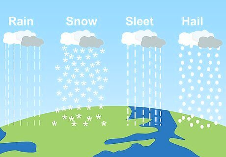
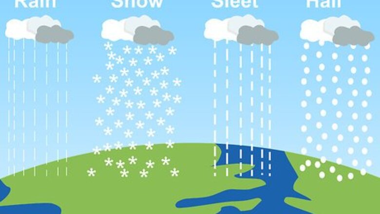
Understand general concepts of precipitation. What most people are concerned with is precipitation, which, in meteorology (the study of weather), is any form of water that falls onto the Earth's surface. Forms of precipitation include rain, hail, snow, and sleet.
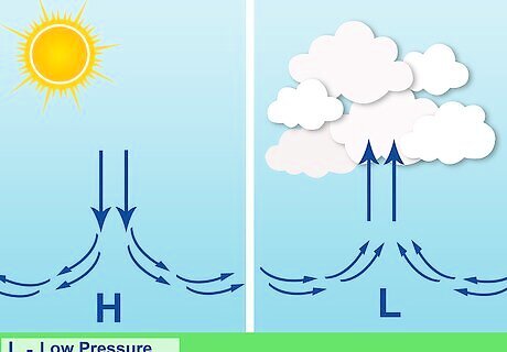
Recognize what a high pressure system is. A major aspect of weather interpretation involves being able to understand the actions caused by differences in air pressure. High pressure implies dry weather. A high pressure system is an air mass that contains denser air because its air is cooler and/or dryer than the surrounding air. Thus, its heavier air falls downward and away from the pressure system's center, like water being poured onto the ground. With high pressure systems, the weather will tend to become clear or clearing.

Understand what a low pressure system is. Low pressure is usually associated with humid air and in some cases, precipitation. A low pressure system is an air mass that has less dense air because its air is moister and/or warmer. Surrounding air draws inward toward the low system's center as the lighter air balloons upward, often causing clouds or precipitation because that moist air cools as it rises. You see this effect when air's invisible water vapor is forced to condense into droplets when it contacts the outside of a cold glass). But droplets won't form if the glass is only slightly cool ...thus, rising low pressure air will only produce rain if it gets up where the air is cool enough to condense the water vapor into droplets too heavy to be kept aloft by the rising air. (Clouds are simply water droplets that are small enough to be kept aloft). With very low pressure systems, storms are on the way (if they aren't there already). Clouds begin to form and move across the sky -thunderhead clouds forming when moist air is thrust very high. Sometimes tornadoes form when very high pressure air collides with very warm, moist low pressure air.
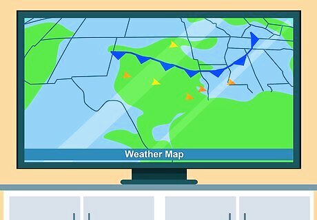
Study a weather map. Watch out for one on the TV news, online, or in your local newspaper. (Other sources may include magazines and books, but they may not be current.) Newspapers are a convenient method to find a weather map as they are cheap, reliable, and can be cut apart so you can carry them with you while learning to interpret the symbols.
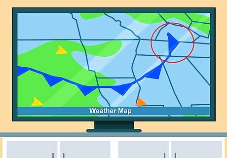
Analyze a small portion of your weather map. If possible, find a map covering a smaller area – these can be easier to interpret. Focusing on a larger scale may be difficult for a beginner. On the map, notice the location, lines, arrows, patterns, colors, and numbers. Every sign counts and all are different. Use weather map symbols to decode the forecast. "Reading this article helped me start paying closer attention to the symbols on weather maps. Just the other day I noticed a low pressure system and incoming cold front. That allowed me to predict heavy rain was headed our way before it arrived. My family's camping trip was saved thanks to decoding the map ahead of time." - Frank J. Anticipate changes from approaching fronts. "The part explaining warm, cold, and occluded fronts was most helpful to me. Now, I can identify the different colored lines and symbols indicating fronts on a weather map. Knowing a cold front brings wind and rain helps me get ready to batten down the hatches. And when I see a warm front approaching, I know to expect a gradual rainstorm before clearing up." - Nick M. Engage students with accessible weather concepts. "As a middle school science teacher, I appreciated how this article uses straightforward language and graphics to break down weather maps. Having my students analyze a local forecast map really helps meteorology concepts click. The tips here make this topic approachable for any age group new to deciphering weather maps." - Brian D. Gain confidence in reading complex maps. "I used to find weather maps very confusing, with so many coded symbols and lines to interpret. But by walking through things step-by-step, this article made it all understandable to me. Now, I feel capable of reading a weather map on my own to figure out the coming forecast." - Sheryl P. Did you know that wikiHow has collected over 365,000 reader stories since it started in 2005? We’d love to hear from you! Share your story here.
Reading the Air Pressure
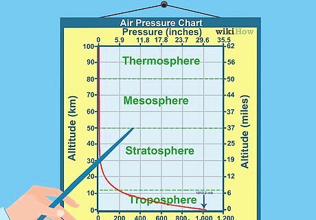
Understand what air pressure measures. This is the weight or pressure the air exerts on the ground and is measured in millibars. It is important to be able to read air pressure because pressure systems are associated with certain weather patterns. The average air pressure system measures 1013 mb (29.92 inches of mercury). A typical strong high pressure system measures around 1030 mb (30.42 inches of mercury). A typical low pressure system measures around 1000 mb (29.54 inches of mercury.
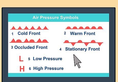
Learn the air pressure symbols. To read air pressure on a surface analysis weather map, check for isobars (iso = equal, bar = pressure) – plain, curved lines that indicate areas of equal air pressure. Isobars play a major role in determining the speed and direction of wind. When the isobars form concentric closed (but not always round) circles, the smallest circle in the center indicates a pressure center. This can be either a high-pressure system (depicted by an "H" in English, "A" in Spanish) or a low pressure system (depicted by an "L" in English, "B" in Spanish). Air does not flow "down" pressure gradients; it flows "around" them due to the Coriolis effect (Earth spinning). Hence, wind direction is indicated by the isobars, counterclockwise around lows (cyclonic flow) and clockwise around highs (anticyclonic) in the northern hemisphere, thus creating wind. The closer the isobars are to one another, the stronger the winds.
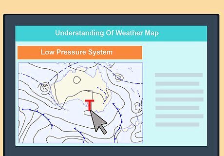
Learn how to interpret a Low Pressure System (Cyclone). These storms are characterized by increased cloudiness, winds, temperatures, and chance of precipitation. They are represented on a weather map by isobars that are close together with arrows traveling clockwise (Southern Hemisphere) or counter-clockwise (Northern Hemisphere), usually with a "T" in the middle isobar, which forms a round circle (the letter can vary, however, depending on the language the weather report is presented in). Radar imagery can show low-pressure systems. Tropical cyclones (South Pacific) are also named hurricanes around America or typhoons in coastal Asia.
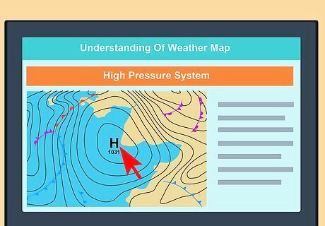
Learn how to interpret a High Pressure System. These conditions indicate clear, calm weather with reduced chance of precipitation. Drier air usually results in a greater range of high and low temperatures. They are represented on a weather map as isobars with an "H" in the middle isobar and arrows showing which direction the wind is flowing (clockwise in Northern Hemisphere, counterclockwise in the Southern Hemisphere). Like cyclones, they can also be shown with radar imagery.
Interpreting the Types of Fronts
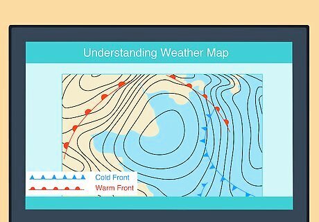
Observe the types and movement of fronts. These mark the boundary between warmer air on one side and colder air on the other. If you are close to a front and you know the front is moving towards you, you can expect a change in weather (e.g. cloud formation, precipitation, thunderstorms, and wind) when the front boundary passes over you. Mountains and large bodies of water can distort its path. On a weather map, you will notice some lines that have semi-circles or triangles on either side, or both. These indicate the boundaries for various types of fronts.
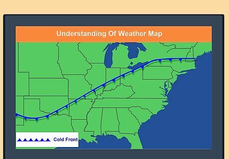
Analyze a Cold front. With these weather patterns, rainfall can be torrential and wind speeds can be high. Blue lines with triangles on one side represents cold fronts on weather maps. The direction the triangles point is the direction in which the cold front is moving.
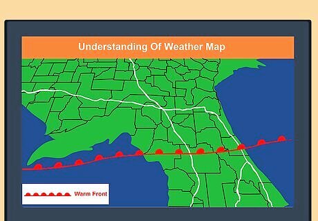
Analyze a Warm front. These often bring a gradual increase in rainfall as the front approaches, followed by prompt clearing and warming after the front passes. If the warm air mass is unstable, the weather might be characterized by prolonged thunderstorms. A red line with semi-circles on one side represents warm fronts. The side the semi-circles are on represent the direction in which the warm front is heading.
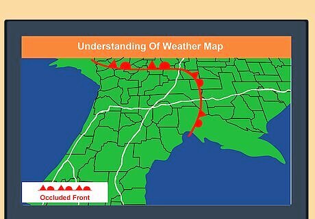
Study an Occluded front. These are formed when a cold front overtakes a warm front. They are associated with various weather events (possibly thunderstorms) depending on whether it is a warm or cold occlusion. The passing of an occluded front usually brings drier air (lowered dew point). A purple line with semi-circles and triangles both on the same side represents occluded fronts. Whichever side they're on is the direction the occluded front is going.
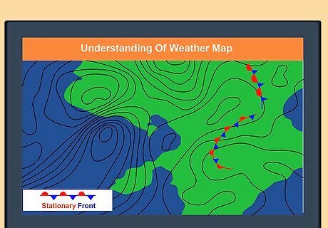
Analyze a Stationary front. These indicate a non-moving boundary between two different air masses. These fronts have long continuous rainy periods that linger for extended periods in one area and move in waves. A semi-circle bordering one side and triangles along the opposite side represents that the front is not moving in any direction.
Interpreting Other Weather Map Symbols
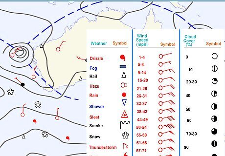
Read the station models at each point of observation. If your weather map has station models, each one will plot the temperature, dew-point, wind, sea level pressure, pressure tendency, and ongoing weather with a series of symbols. Temperature is generally recorded in Celsius degrees and rainfall is recorded in millimeters. In the US, temperatures are in Fahrenheit and rainfall is measured in inches. Cloud cover is indicated by the circle in the middle; the extent to which it is filled indicates the degree to which the sky is overcast.
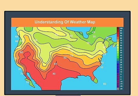
Study the lines on the weather map. There are many other lines on weather maps. Two of the most important kinds of lines indicate isotherms and isotachs. Isotherms – These are lines on a weather map that connect points through which the isotherm passes have the same temperature. Isotachs – These are lines on a weather map that connect points where the isotach passes have the same wind speed.
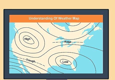
Analyze the pressure gradient. A number on the isobars, such as "1008", is the pressure (in millibars) along that line. The distance between isobars is referred to as the pressure gradient. A large change in pressure over a short distance (i.e. close isobars) indicates strong winds.
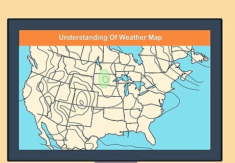
Analyze wind strength. Wind barbs point in the direction of the wind. Lines or triangles coming off the main line at an angle indicate wind strength: 50 knots for every triangle, 10 knots for every full line, 5 knots for every half line.




Comments
0 comment