views
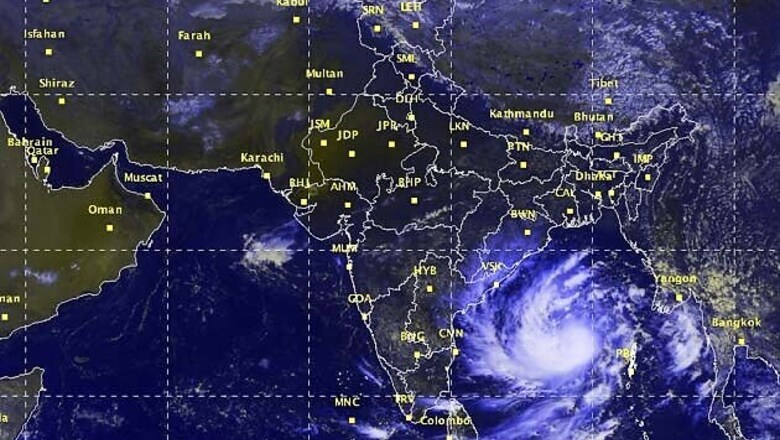
New Delhi: Cyclonic storm Hudhud will cross the north Andhra Pradesh coast around Visakhapatnam by the forenoon of October 12, 2014. Hudhud has moved into a West-Northwestward direction from East Central Bay of Bengal and intensified into a severe storm. Cyclone Hudhud lay centred at about 750 km southeast of Gopalpur and east-southeast of Visakhapatnam near latitude 13.8ºN and longitude 89.0ºE at 8:30 am on October 9, 2014.
According to a bulletin issued by the India Meteorological Department the cyclonic storm would continue to move West-Northwestwards and intensify further into a very severe cyclonic storm during the next 24 hours.
The Met Department has issued a warning for north Andhra Pradesh coast and south Odisha. These areas will witness heavy rainfall. Under the influence of the system, rainfall at most places with heavy (6.5 - 12.4 cm) to very heavy falls (12.5 - 24.4 cm) at a few places and isolated extremely heavy falls (= 24.5 cm) would occur over east Godavari, Visakhapatnam, Vijayanagaram and Srikakulam districts of north coastal Andhra Pradesh and south Odisha from the evening of October 11 onwards. Rainfall would occur at most places with heavy to very heavy rainfall at isolated places over remaining districts of Andhra Pradesh and north coastal Odisha during the same period.
Squally wind speed reaching 50-60 kmph gusting to 70 kmph would commence along and off north Andhra Pradesh and south Odisha coasts from the morning of October 11 onwards. The wind speed would increase to 130-140 kmph gusting to 155 kmph from October 12 morning along and off north Andhra coast and 80-90 kmph along and off south Odisha coast.
Sea condition would be rough to very rough from October 11 morning. It would gradually become phenomenal from October 12 morning onwards along and off north Andhra coast and very rough to high along and off south Odisha coast.
Storm surge of about 1-2 meters above astronomical tide would inundate low lying areas of east Godavari, Visakhapatnam, Vijayanagaram and Srikakulam districts of north coastal Andhra Pradesh at the time of landfall.
Under the influence of system, extensive damage to kutcha houses is expected. Partial disruption of power and communication lines is also likely while minor disruption of rail and road traffic may take place. There is a potential threat from flying debris and flooding will also take place in some area.
The Met has also warned fishermen against venturing into the sea and asked for suspension of fishing operations in area of influence of cyclone. People in affected areas should remain at safe places around landfall period.


Comments
0 comment