views
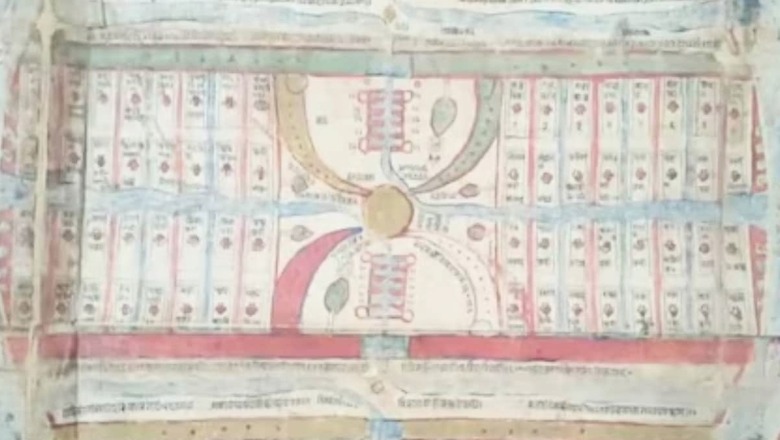
Since ancient times, maps have been created to provide geographical information about the world. But there is a unique map in the city of Baghpat, Uttar Pradesh, that is considered one of a kind in the world. Historians claim that there are only two such maps in the world. One is in India while the other one is kept in the United Kingdom. The special feature of these maps is that they have been made using natural colours. The map depicts rivers, mountains and other natural landmarks, all illustrated with natural colours.
Historian Amit Rai Jain explained that Jainism possesses a world map which is known as the ‘Aḍhai Dvīp’. It was created around the 12th and 13th century. This map was reportedly drawn on a cloth. The colours used were extracted from the plants, fruits, and vegetables available at that time, making the map a unique example of India’s traditional art style.
The historian further mentioned that on the map you can see a unique depiction of geographical and astronomical phenomena. It finely shows the positions of rivers, mountains, seas, and other geographical landmarks. Historians and researchers who specialise in Indian history are continuously studying this map, aiming to uncover its hidden secrets and bring them to the attention of the world. Researchers from foreign nationals are also trying to uncover the secrets hidden in these maps.
Historians from around the globe believe that this map offers a unique opportunity to showcase India’s ancient knowledge and culture to the world. This map is one of a kind and holds information from that time. While there are other such maps in existence, they are slightly more recent and were created a few years after this map was made. Another map from this time is presently placed in the British Museum. According to reports, a professor from London University is conducting a comparative study of it alongside the map from India to unveil the secrets hidden.


Comments
0 comment